
Guest post by Abdul Rahman, Fulbright scholar working with Earth Genome this year.
During my time at Earth Genome, I’ve been experimenting with Google’s AlphaEarth (AE) embeddings and the best ways to incorporate them into a second-stage classifier, trying to improve our prior cattle facility detections for the non-profit coalition, Climate TRACE. Cattle facilities are a significant source of greenhouse gas emissions, particularly methane, and pinpointing their locations at continental scale narrows down the source and helps devise targeted mitigation strategies.1 2 My previous work in this direction was more about segmenting facilities and had much stricter labelling requirements, though lessons learned about spatial priors directly fed into our current pipeline.
Methodology
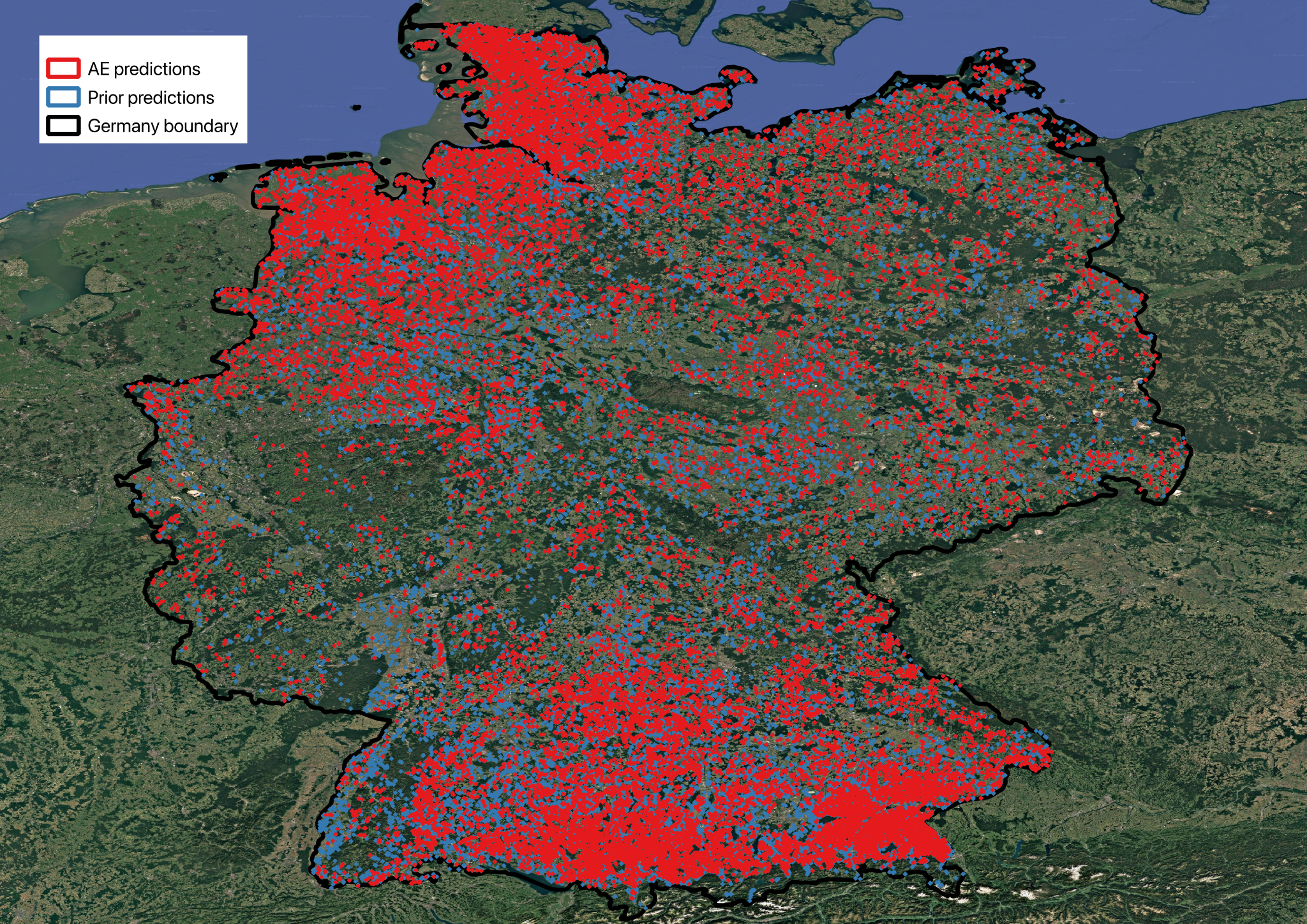
Spatial priors are 320m resolution candidate facility locations with a significant number of false positives (FPs) mixed in, generated by a first-stage classifier using SSL4EO embedding set building on core Earth Index technology. The AE classifier is trained on top of those candidate predictions at 160m resolution using a lightweight MLP, and cleans them up by bringing in an additional cattle facility signal. Although different model types were experimented with, including logistic regression and hyperparameter-tuned MLPs, the best one was a barebones, default perceptron with features scaled and early stopping enabled, indicating our approach’s scalability. Figure 1. shows prior predictions spread in Germany, and locations in which AE fired.
Increasing resolution normally requires finding new training locations and labeling them from scratch. What also adds to our pipeline’s scalability is that the AE classifier recycles locations used by stage one; we manually refine their labels to a higher resolution and add new ones nearby. We also include a set of random negative labels, ensuring correct handling of forests, fields, and other common natural landscapes.
The features come from a 64-dimensional AE embedding set at 10m × 10m per pixel. We summarise each dimension with four statistics, mean, standard deviation, minimum and maximum, which gives 256 features for each 160m patch.
At inference time we want to get the most out of our model while still ensuring footprints are big enough to cover entire facilities, so we run the same model in two passes: first at a stride of 160m, filtering out candidate locations that AE doesn’t predict, and then a second round at a stride of 80m. Our experiments show that using only a stride of 80m results in a large number of FPs, though still fewer than stage one.
Results from Germany
In Germany, the industry is overwhelmingly dairy-focused rather than meat-focused: 85% of all cows belong to dairy herds and only 15% to suckler herds, and an average facility holds 86 animals. 3 4 These facilities are identifiable in satellite images by their large, cylindrical manure digesters, feed stores under blue/white tarps, and barn-style structures.
However, some of these features, such as manure digesters, may be shared with biogas plants that do not necessarily house cattle, while others, such as feed stores, may be tucked inside villages and hence are difficult to spot. Barns can be indistinguishable from nearby village buildings as well, making Germany one of the hardest countries for locating cattle facilities.
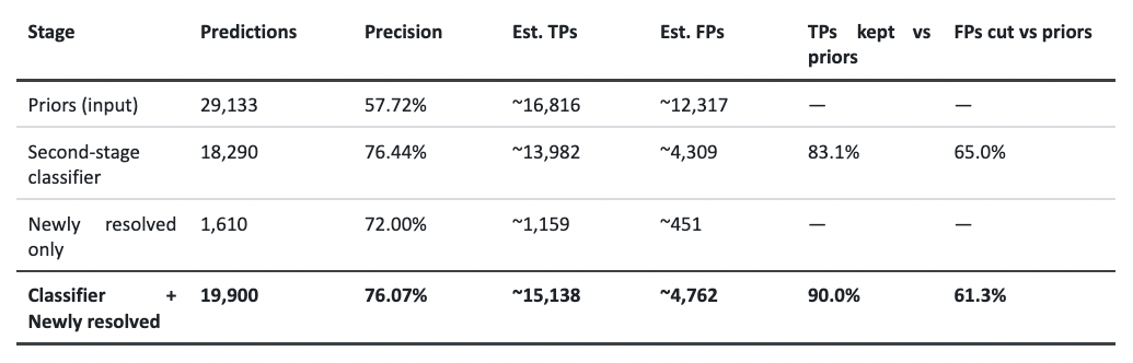
Surprisingly still, our pipeline managed to do well. We were able to increase precision by ~32% (18 percentage points) while retaining ~90% of stage one’s estimated facilities and reducing footprint area by ~45%. The footprint reduction was a natural consequence of a higher resolution, and had some interesting knock-on effects.
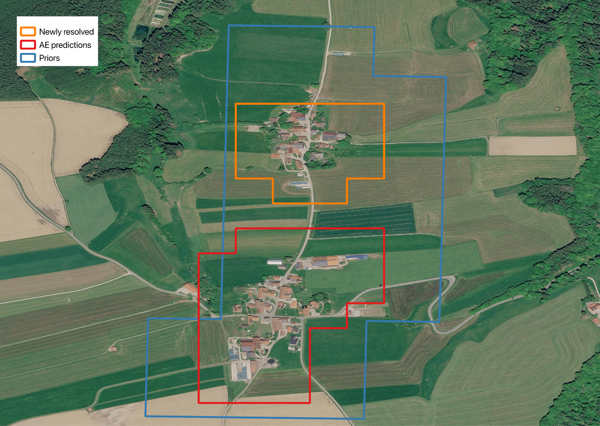
Due to an increase in resolution, AE can separate facilities that were lumped together in some single coarse prior. We identify an additional 1,610 cattle facilities, or 8% of the total, through this mechanism. The table below summarizes our findings while Figure 2. zooms into a prior example with newly resolved facilities also shown.
There is one caveat, however, that is worth mentioning. In this pipeline, we can only be as good as our prior results; that is to say, any facility that stage one misses will also be missed by the second stage. But recall is not our goal here; it is improving precision and cleaning up candidate locations. A GitHub repository containing all code files and data can be found here.
The case for ensembles and domain-specific FMs
The entire premise behind this current lot of Foundation Models (FMs) was to reduce time spent on any given geospatial task by learning generic, representational embeddings for the whole globe. They promised scale, an entire planet, and scope, any conceivable geospatial task. Our results point to a different picture.
Even after accounting for changes in resolution and labels, an 18-point increase in precision hints at something deeper. If SSL4EO embeddings and AE encoded the same information about a facility, and about false positives that look like one, stacking a classifier on AE would mostly reproduce those errors. Instead it removes two thirds of FPs while holding on to most TPs, which says both embedding sets capture different facility signals. That was clearer still in our Great Britain run, where, with each classifier at its best operating point, we saw facilities one model missed and another caught, and vice versa.
This to me is the key empirical observation: there is value in ensembling SSL4EO- and AE-based models, and that suggests that they have generated genuinely distinct "views" of terrestrial scenes. To some extent we would expect this, as AE encodes image time series at 10m/pixel, while SSL4EO is trained on static 224 x 224-pixel patches. It’s interesting to see these modeling choices express themselves in a meaningful way. However, ensembling can be interpreted as undercutting the ambition of general purpose FMs, adding a second inference pass and a second set of features, complexity FMs were meant to remove in the first place.
There are conceivable alternatives. One could stack SSL4EO + AE embeddings into a single feature set and build a single classifier. Our internal, initial benchmarking shows that stacked AE + other embedding sets modestly outperform AE or those various "others" alone. Another alternative we could look to are domain specific FMs (agricultural, urban policy, and so on): similar in scale to general-purpose FMs but tighter in scope, pretrained on imagery and targets relevant to a particular domain; they would sit between the older approach of bespoke geospatial ML models and the search for a single optimal FM to solve all problems. More thorough tests are needed though, before any of this is settled.
At global scale even a small gain compounds, and our results point to value to be found in squeezing the signal -- via ensembling, stacked embeddings, or a potential domain-specific FM -- dispersed across several general-purpose FMs.
References
1. Food and Agriculture Organization of the United Nations. 2023. Pathways towards Lower Emissions: A Global Assessment of the Greenhouse Gas Emissions and Mitigation Options from Livestock Agrifood Systems. Rome: FAO. https://doi.org/10.4060/cc9029en
2. Handan-Nader, Cassandra, and Daniel E. Ho. 2019. "Deep Learning to Map Concentrated Animal Feeding Operations." Nature Sustainability 2 (4): 298–306. https://doi.org/10.1038/s41893-019-0246-x
3. Thünen Institute of Farm Economics. n.d. "Beef and Sheep." Johann Heinrich von Thünen Institute. Accessed September 4, 2026. https://www.thuenen.de/en/institutes/farm-economics/production-systems/beef-and-sheep
4. Statistisches Bundesamt (Destatis). 2026. "Holdings with Cattle and Stock of Cattle." Federal Statistical Office of Germany. Accessed September 4, 2026. https://www.destatis.de/EN/Themes/Economic-Sectors-Enterprises/Agriculture-Forestry-Fisheries/Animals-Animal-Production/Tables/5-holdings-with-cattle-and-stock-of-cattle.html
Other articles
.png)
Amazon Mining Watch: August 2026 Update
We are releasing new machine learning models and a new data series, in a full data replacement update for Amazon Mining Watch, through the second quarter of 2026.


The AI Knowledge Problem
Report out on building decision support tools for nature credit project design
.png)