.svg)
Use cases
.webp)


.webp)
Monitor illegal mining operations - Amazon Mining Watch
Earth Index is the core technology powering Amazon Mining Watch, a platform for monitoring illegal, environmentally-destructive gold mining in the world’s largest rainforest. Earth Index uses machine learning to recognize characteristic landscape change over time and flag new mining activity as it begins.
.webp)
.webp)
.webp)
.webp)


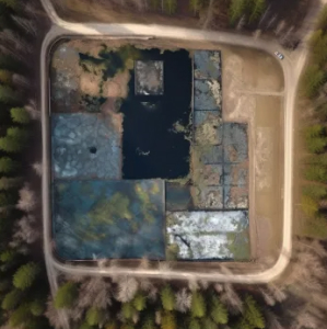


Identifying unmapped wastewater ponds
Proper wastewater disposal is a major environmental justice and public health priority, but many semi-formal wastewater ponds remain unmapped. Earth Index leverages the diagnostic structural and spectral characteristics of wastewater ponds to detect new or unreported ponds.
Please note that the chat interface displayed in this example is experimental work in progress.


Find anything
Ordering satellite imagery and searching open source catalogs is tedious. Scanning low-resolution thumbnails for required features is time-consuming. Earth Index streamlines the process, making image catalog searches more efficient. Find anything, anywhere, in less than a day.


Key features
Earth Index uses our large earth observation model to find places that are similar to each other and identify locations that have changed over time in similar ways. Using image embeddings, a "DNA sequence" which uniquely identifies features in a stack of imagery, the technology allows for efficient searching and classification workflows.
Leverage the power of multispectral data
From crop mapping to carbon biomass estimation, Earth Index can draw on descriptive multispectral data to find what you’re looking for.
Search over time
The world is dynamic. Earth Index is designed with this principal at its core, and easily allows for a user to monitor locations that have changed over time in similar ways.
Embeddings designed for structural searches
Built using the latest geospatial machine learning and computer vision models, Earth Index is designed to recognize spatial patterns in imagery.
Efficient image compression
Intelligent image compression allows for rapid searching, classification, and retrieval.
Flexible deployment on any cloud platform
Built with the intention to operate flexibly at scale using cloud-based platforms such as Google Earth Engine, GCP, and AWS.
Why we built it
Earth Genome generates environmental intelligence for decision makers. Earth Index was born from the need to more efficiently detect and monitor change on the planet. Our projects over the years have required finding things that have never been accounted for or things that change over time – discovering new mines in the Amazon, creating an inventory of all high concentration cattle operations in the United States, finding undocumented waste sites in Indonesia or distinguishing wheat fields from other types of agriculture in Ukraine. We purpose built the tools to search within an ocean of pixels – across space and time. Now, Earth Index allows us – or anyone – to build these kinds of datasets in a way that is better, faster, and cheaper than ever before.
Discover our stories
See how Earth Index unlocks data-driven action for climate and conservation.

Become an early adopter
Join our early adopter program or tell us about the things that you need to find. No spam, only monthly updates about the tool.